Isla Salas y Gómez
Geography
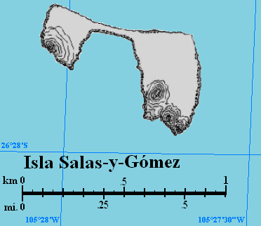
It is a volcanic rock that consists of two hills joined by a narrow isthmus. The island is 770 meters long and about 500 meters wide. It is a Chilean possession. A lighthouse is located on the island.
Other names: Motu Motiro Hiva, Manu Motu Motiro Hiva.
Location: 26”27’S, 105”28’W (390 kilometres east of Rapa Nui).
Area: 15 ha (larger, eastern part 11 ha; smaller, western hill 4 ha).
Highest point: 30 meters above sea-level.
Population: uninhabited.
Population: uninhabited.
 |
| Map of Salas y Gomez |
History
The natives from Rapa Nui visited Sala y Gomez before the island was discovered by Europeans, in order to collect birds and eggs.
23 August 1793 - José Salas Valdés discovered the island.
1805 – it was explored by Jose Manuel Gomez. Other recorded visits took place in 1806, 1817, 1825, 1875 and 1917.
1888 – Salas y Gomez was annexed by Chile.
6 October 2010 - Marine Protected Area Parque Marino Sala y Gómez was created. It consists of 150,000 km2 of the Pacific Ocean around the island.


Source
Pacific Islands Volume II Eastern Pacific Naval Intelligence Division 1943
Brak komentarzy:
Prześlij komentarz