środa, 31 października 2018

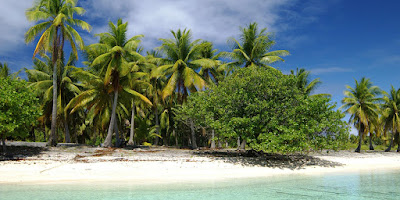
Hiti Atoll

Hiti Atoll

Geography
Hiti is an atoll in the Tuamotu Archipelago. It is 9 km long and 6 km wide.
Another name: Hiti-rau-mea
Location: 16°40′S 144°07′W.
Area: 3 km² (land) and 15 km² (lagoon)
Population: Uninhabited.
Map of Hiti Atoll

Hiti Atoll

History
1820 - Fabian Gottlieb von Bellingshausen discovered the atoll for Europe.
1840 – The atoll was visited by Charles Wilkes.

Sources:


sobota, 27 października 2018

Makemo Atoll

Makemo Atoll

Geography
Makemo is an atoll in the Tuamotu Archipelago. It is 69 km long and 16.5 km wide. Its lagoon is fourth largest of the Tuamotu Archipelago.
Other names: Rangi-kemo, Te Paritua, Philip
Location: 16°35′55″S 143°39′41″W
Area: 56 km² (land) and 603 km² (lagoon)
Population: 832 (2012)
Largest settlement: Pouheva (pop. 600)

Map of Makemo Atoll

Makemo Atoll

History
10 March 1803 – The atoll was discovered for Western world by English pearl merchant John Buyers on the brig Margaret. He named it Phillips Island.
1976 - Makemo territorial (domestic) airport was opened.

Makemo Atoll

Makemo Atoll

Makemo Atoll

Makemo Atoll

Makemo Atoll

Makemo Atoll

Sources

niedziela, 21 października 2018

Katiu Atoll

Katiu Atoll

Geography
Katiu is an atoll in the Tuamotu Archipelago. It is 27 km long and 12.5 km wide.
Other names: Taungataki, Atina, Saken
Location: 16°25′S 144°22′W. It is located 23.5 km west of Makemo Atoll.
Area: 10 km² (land) and 232.5 km² (lagoon)
Population: 250 (2012)
Largest settlement: Toini

Map of Katiu

Katiu

History
15 July 1820 - Fabian Gottlieb von Bellingshausen discovered the atoll for Europe. He called it Saken Island.
20 December 1840 - Charles Wilkes visited the atoll.
2001 - A territorial (domestic) airfield was inaugurated.

Katiu

Katiu

Katiu

Katiu

Katiu

Sources:

piątek, 19 października 2018

Anaa Atoll

Anaa Atoll

Geography
Anaa is an atoll in the Tuamotu Archipelago. It is 29.5 km long and 6.5 km wide.
Other names: Nganaa-nui, Ara-ura
Location: 17°20′31″S 145°30′31″W. It is located 350 km to the east of Tahiti.
Area: 38 km² (land) and 90 km² (lagoon)
Highest elevation: 11 m (unnamed)
Population: 497 (2012)
Largest settlement: Tukuhora (population 350)

Map of Anaa Atoll

Anaa Atoll

History
17th century – Soldiers from Anaa atoll dominated the north-west of the Tuamotus.
10 February 1606 - Pedro Fernández de Quirós discovered the atoll for Europe. He named it Conversión de San Pablo.
1768 - Louis Antoine de Bougainville sighted the atoll.
1769 – James Cook sighted Anaa atoll. He called it Chain Island.
1 November 1772 - Anaa was visited by Spanish explorer Domingo de Boenechea. The atoll was named Isla de Todos los Santos.
1852 - The missionary competition between Mormons of North America and French Catholics led to a revolt and an intervention of French colonial troops.
1878, 1906, 1983 - Anaa suffered severe hurricane damages.
1976 – Inauguration of a territorial airport.

Anaa Atoll

Anaa Atoll

Anaa Atoll

Anaa Atoll

Anaa Atoll

Sources

piątek, 12 października 2018

Tahanea Atoll

Tahanea Atoll

Geography
Tahanea is an atoll in the Tuamotu Archipelago. It is 48 km long and 15.2 km wide.
Another name: Tchitchagoff
Location: 16°50′S 144°45′W. The atoll is located 12 km to the east of Faaite Atoll.
Area: 7.7 km² (land) and 522.5 km² (lagoon)
Population: The atoll is Uninhabited. However, it is visited occasionally by islanders from neighbouring atolls.

Map of Tahanea

Tahanea

History
9 November 1774 - Domingo de Boenechea on ship Aguila discovered the atoll for Europe. He named it San Julián.
1820 - Fabian Gottlieb von Bellingshausen visited the atoll. He named it Tchitchagoff.

Tahanea

Tahanea

Tahanea

Tahanea

Sources:


środa, 10 października 2018

Faaite Atoll

Faaite Atoll

Geography
Faaite is an atoll in the Tuamotu Archipelago. It is 20 km long and 10.5 km wide.
Other names: Faaiti, Miloradowitch
Location: 16°43′S 145°19′W. Faaite is located 60 kilometres to the north of Anaa Atoll.
Area: 8.87 km² (land) and 227 km² (lagoon)
Population: 401 (2012)
Largest settlement: Hitianau (pop. 246)

Map of Faaite

Faaite

History
11 February 1606 – The atoll was discovered for Europe by Pedro Fernández de Quirós.
1802 - John Turnbull rediscovered Faaite.
1820 - Fabian Gottlieb von Bellingshausen visited the atoll. He named it Miloradowitch.
2 September 1987 - Six people were thrown into the fire (some of them by their own children) because the islanders were convinced that they were possessed by the devil.
1992 – The domestic airport was opened.

Faaite

Faaite

Faaite

Sources:

piątek, 5 października 2018

Raraka Atoll

Raraka Atoll

Geography
Raraka is an atoll in the Tuamotu Archipelago. It is 27 km long and 19 km wide.
Another name: Te Marie
Location: 16°10′S 144°54′W. It lies 17 km to the southeast of Kauehi Atoll.
Area: 7.2 km² (land) and 342 km² (lagoon)
Population: 110 (2012)
Largest settlement: Motupapu


Map of Raraka

Raraka

Raraka

History
2 October 1831 – The first European to visit the atoll was captain Ireland.
September 1838 – Raraka was visited by Jules Dumont d'Urville.
30 August 1839 and 18 December 1840 – The atoll was visited by Charles Wilkes.

Raraka

Raraka

Raraka

Raraka

Raraka

Raraka

Sources: